
All Damavand Camping Sites Guide
Mount Damavand offers various campsites, mountain huts, shelters, and tenting spots along its routes for hiking and trekking tours. This guide provides an overview of these locations, including their basic safety features and facilities, to help you plan your ascent and overnight stays.

Bargah Sevom New Hut and Old Shelter
(lat: 35.9305°, lon: 52.1085°, alt: 4,210 m)
Trekking climbing and ski touring Mount Damavand Iran
Notable Damavand Camps
Mount Damavand Campsites’ Coordinates and Heights
Polour Village Camp (lat: 35.8465°, lon: 52.0605°, alt: 2,270 m).
Rineh Town Camp (lat: 35.8816°, lon: 52.1661°, alt: 2,050 m).
Base Camp – Gosfandsara (lat: 35.9020°, lon: 52.1094°, alt: 3,025 m).
Bargah Sevom Shelter (lat: 35.9305°, lon: 52.1085°, alt: 4,210 m).
Bargah Sevom Hut (lat: 35.9316°, lon: 52.1093°, alt: 4,245 m).
Simorgh Shelter (lat: 35.9564°, lon: 52.0825°, alt: 4,200 m).
Takhte-e Feridoun Refuge (lat: 35.9665°, lon: 52.1341°, alt: 4,380 m).
Nandal Mountaineer House (lat: 36.0303°, lon: 52.1740°, alt: 2,350 m).
Damavand 4000 Shelter (lat: 35.9782°, lon: 52.1112°, alt: 3,996 m).
Damavand 5000 Refuge (lat: 35.9681°, lon: 52.1147°, alt: 4,624 m ).
In addition to these primary camps, you can find numerous campgrounds, hostels, local homes, and mountain resorts near Damavand. These include Hotels and hostels in Abegarm Larijan Thermal Spring SPA and Emamzadeh Hashem, local homes in Polour, and local houses in Lasem.
(lat: 35.9305°, lon: 52.1085°, alt: 4,210 m)
Mount Damavand Hike Trek Climb Ski Tour Guide
Planning Your Stay
Knowing the locations and details of Damavand campsites, shelters, and huts is crucial for Damavand Trekking Tours. This information helps in planning your ascent, organizing your program, and preparing for potential nighttime conditions. The camps along the routes provide various facilities, including restrooms, where you can set up your tent or use the shelters. During peak seasons, it is advisable to make reservations in advance if you plan to stay at one of the Damavand mountain camps.
Experience Mount Damavand with Damavand-Info
Organize an extraordinary adventure to the top of Damavand Peak with Damavand-Info, your trusted guide for hiking and trekking tours. As the leading Mount Damavand trekking tour agency, we specialize in creating safe and unforgettable guided expeditions tailored to all skill levels. Whether you’re a seasoned climber or a hiking enthusiast, our expert Damavand Mountain guides offer the knowledge and support you need to conquer Mount Damavand in Iran. Our wide range of tour packages includes, Damavand trekking tours and Damavand ski tours ensuring there’s something for every adventurer. With years of experience, Damavand-Info transforms your dream of reaching the highest peak in the Middle East into a reality, providing a successful and memorable journey for both beginners and experts.

(lat: 35.8465°, lon: 52.0605°, alt: 2,270 m)
Damavand Hike, Trekk, Climb Ski Tour Guide
Detailed Guide to Damavand Campsites
Mount Damavand is a popular destination for climbers and trekkers. The mountain has several campsites and shelters that provide necessary facilities for those attempting to reach its summit. Here’s a more detailed look at the various campsites along the different routes of Mount Damavand.
Polour Camp
Damavand Camp – First Camp Polour Resort
Polour Complex Camp, established in 2001 by the Iran Climbing Federation, is a key starting point for climbing Damavand via the south or west routes. It is located near Haraz Road in Polour Village, a main route connecting Tehran to the Caspian Sea through Haraz Valley and Haraz River.
The accommodation at Polour Resort includes a hostel with private rooms and public dorms equipped with bunk beds, toilets, hot showers, a kitchen, cooking gear, tap water, electricity, telephone, ADSL, WiFi, and central heating. However, there is currently no clear system for foreigners to book. In Damavand’s crowded seasons, booking private rooms is difficult without a tour operator. Public dorms operate on a first-come, first-served basis.
The resort is open year-round from 6 AM to 11 PM and is ideal for acclimatization and as a starting point for the south and west routes of Damavand. It is well-equipped with necessary amenities including mobile network coverage and mountain gear availability. The facility is well-managed and comfortable in cold weather.
A disadvantage is that its popularity can lead to crowding during peak climbing season, so booking is recommended. There is no specific weather station for Polour Village; the nearest data comes from Mount Damavand at 4909 meters. Detailed snow forecasts are available on snow-forecast.com.
It is important to avoid unidentified accommodations in nearby towns or open areas and use Iran Mountain Federation Campsites. Polour Resort is also known as Panagah Polour, Polur Resort, Poolor Hostel, and Poolour Lodge. Haraz Road passes through the Alborz Mountains, connecting Tehran to Mazandaran province and the Caspian Sea.

(lat: 35.8816°, lon: 52.1661°, alt: 2,050 m)
Reineh Camp
Damavand Camp – First Camp Reineh
Rineh Hut, located in Rineh Town in the Larijan district, is the oldest mountaineering resort for hiking Damavand in Iran. Built in 1939 and reconstructed in 1969, it has not seen major updates since. This small camp was the main resort for climbers before the Polour complex campsite was established in 2004. Recently, it has been losing popularity among climbers.
Renyeh Hut is recommended for those travelling from the north of Iran, such as Gilan or Mazandaran province. However, for those travelling from Tehran, Camp 1 Polour Hut is a better option as it offers more facilities and a shorter route to Damavand.
The Reineh Resort, at an altitude of 2078 meters, has basic accommodation including one public room and one private room with bunk beds, an external toilet, hot water, shower, a kitchen, and cooking gear. It is equipped with central heating, a telephone line, electricity, and water taps with both hot and cold water. Two mobile networks are available in the area.
Advantages of Reineh Resort include its access to the south face of Damavand from the north of Iran and its basic facilities for accommodation and acclimatization. However, it has disadvantages: it is further from Tehran than Polour Resort has fewer facilities, and needs major reconstruction.
For climbers from Tehran, the recommended route is through Polour Hut. The route to Reineh Town involves taking the Haraz Road to Pol e Moon Junction, then to Reineh Town, which is about 2.5 hours by car from Tehran.
Reineh Town is a small, picturesque town on the south slopes at the foot of Mt. Damavand in Mazandaran province. It is the capital of the Larijan district of Amol County. It is important to avoid using unidentified places for accommodation and instead use Iran Mountain Federation Campsites.
Coordinates for Reineh Hut:
Altitude: 2078 m Latitude: 35-52-58 N Longitude: 52-09-58 E
Alternate spellings include Reyneh, Rayneh, Reneh, and Rehneh. In Persian, it is written as رینه، شهر رینه (pronounced ray neh).
(lat: 35.9020°, lon: 52.1094°, alt: 3,025 m)
Mount Damavand Trekking & Ski Touring Guide
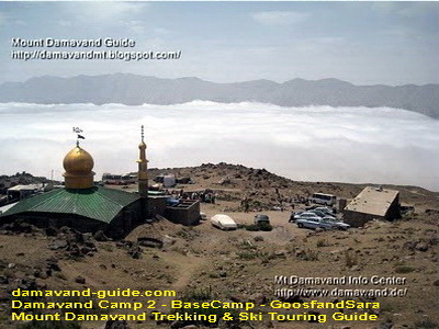
Gosfandsara Camp
Damavand Campsites – Base Camp Shelter
The Damavand Base Camp, also known as Camp II, GoosfandSara, or the Mosque, is a key starting point for Mount Damavand trekking via the southern route. Situated at an altitude of 3,040 meters above sea level, it features a small mountain shelter (refuge), a mosque called Saheb Zaman (or Saheb al-Zaman), and a sheepfold.
During the summer climbing season, climbers and their equipment are transported to this site using off-road vehicles such as 4WD Jeeps and Land Rovers. While some water, food, and drink are available at the Damavand base camp, it is highly recommended to bring your supplies. Mules and porters are available to carry equipment to the final campsite, Camp 3 Bargah Sevom.
This Damavand Camp is not ideal for accommodation or acclimatization during the busy summer climbing season. It tends to be crowded, noisy, and dirty, filled with people and vehicles. In winter, the gravel road leading to Base Camp is often blocked by heavy snowfall, making it inaccessible by car. The winter starting point for Mount Damavand is typically at the gravel road junction (GPS Landmark 5- Gravel Road Junction1). During the cold season, this base camp is generally remote and less crowded, and you may use the shelter or mosque for accommodation.
The Goosfand Sara camp is not ideal for accommodation or acclimatization during the summer season due to overcrowding, noise, and dirt. For a better experience while trekking Mount Damavand, consider using Camp 1 Polour or Camp 3 New Hut. However, if you decide to stay at Goosfand-Sara, it is advisable to bring your own tent and set it up a few hundred meters away from the main area for more comfort and privacy.
The shelter has two old rooms, but they are currently unsuitable for use as the doors and windows are damaged. The mosque has a vacant room, but it tends to be crowded during the summer. For better comfort and privacy, bring and use your tent, setting it up at a distance from the main area. It is recommended to plan your accommodations carefully and consider alternative campsites to avoid the issues at GoosfandSara.
Goosfand Sara is primarily used during the summer season as the starting point of the South route for Damavand climbing tours. It is accessible by car, and mule and porter services are available. Some food, drinks, and water are available, and there is mobile network coverage. However, it is not a good campsite for Mount Damavand as it needs major reconstruction. The old shelter/refuge has no facilities, and the area often lacks running water. It is noisy, crowded, dirty, and not suitable for foreign travellers. The area is overrun by people and cars, and there are no proper toilets or management.
The coordinates for Goosfand Sara are latitude 35.9020°, longitude 52.1094°, and altitude 3,025 meters. The transfer from Camp 1 Polour to Camp 2 Base via gravel road takes about one hour by car in summer, and more by foot in winter. The ascent to Camp 3 Bargah-e Sevom takes 4 to 6 hours by slow walk, while the descent takes 2 to 3 hours.
Goosfand Sara is also known by other names such as Goosfand Sara ye Ehsan, Masjed, Masjed Saheb al-Zaman, and Alaf Chin. In English, it is referred to as Base Camp, Mosque, Base shelter/refuge, or Sheepfold.
To reach Camp 2 Base (Goosfand Sara) from Camp 1 (either Polour or Reyneh), it is recommended to book a suitable car in advance. The drive to Camp 2 Base typically takes about one hour. Use strong 4WD vehicles such as Land Rovers, Jeeps, or patrol cars, and avoid using mini trucks.

(lat: 35.9305°, lon: 52.1085°, alt: 4,210 m)
Mount Damavand Hike Trek Climb Ski Tour Guide
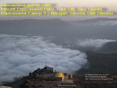
Bargah-Sevom Camp
Damavand Camp – Bargah Sevom Campsite
Mount Damavand Camp III, also known as Bargah Sevom, is the final campsite on the southern route for trekking Mount Damavand in Iran. It features an old shelter (refuge), a new hut built in 2009, a couple of igloos, and several flat areas suitable for tenting. The New Hut has become more popular due to its range of services.
Accommodation options at Bargah Sevom include the New Hut, which offers basic amenities for added comfort and protection; the Old Shelter, which is simpler and less comfortable during crowded summer months; the tenting area, allowing climbers to set up their tents for flexibility and privacy; and the igloos, adventurous and well-insulated snow shelters.
The location of Camp III is at latitude 35.9305°, longitude 52.1085°, and an altitude of 4,210 meters. The Old Shelter holds historical significance as the oldest Damavand mountain shelter, but it can be overcrowded during peak climbing seasons, so climbers are advised to bring their tents for a more private stay. During the summer, the campsite provides limited amenities, including basic food, water, and rental options for tents, making it a practical stop for those who prefer to bring their own gear.
Acclimatization at Camp III is crucial due to the high altitude (4,200 masl). Spending a night or more at this elevation helps climbers adapt to reduced oxygen levels, reducing the risk of Damavand altitude sickness (Acute Mountain sickness – AMS). Climbers often follow a “climb high, sleep low” strategy, ascending to higher altitudes during the day and returning to lower camps to sleep.
Proper accommodation at Camp III is essential due to the high altitude and harsh Damavand weather conditions. Climbers must come prepared with high-quality sleeping bags, insulated clothing, and sufficient food supplies. Visit also Damavand Equipment List. The camp provides basic facilities, including a secure shelter, limited mobile network coverage, and an outside toilet.
When climbing Mount Damavand from the south side, climbers should be aware of the two main ridges: Loumer Ridge on the left and South Ridge on the right. These ridges almost run parallel and meet around 5,000 meters near the Damavand Icefall. For descending, the “Shen Ski” or scree trail between these two ridges offers a smooth and easy descent.
The trek from Camp II Basecamp to Camp III Bargah Sevom takes approximately 3-5 hours. The ascent from Camp III Bargah to the Damavand Summit takes about 5-7 hours, while the descent takes about 3-4 hours. Historical photos from 2006 and 2010 show the trail from Camp III to the summit before and after the construction of the new hut. The Damavand Camp 2 to Camp 3 trekking map provides detailed tracks, essential for climbers preparing to ascend Mount Damavand.

(lat: 35.9316°, lon: 52.1093°, alt: 4,245 m)
Mount Damavand Hiking Trekking Tour Guide
Damavand Camps – Camp 3 Hut
Damavand Camp III – Bargah Sevom New Hut
Mount Damavand Camp III, known as Bargah Sevom, is situated at 4,250 meters on the southern route of Mount Damavand, Iran. This campsite is a crucial stop for hikers and trekkers aiming to summit Mount Damavand. The new hut, constructed by the Iran Mountaineering & Climbing Sports Federation and completed in 2009, is located near the old shelter at 4,220 meters.
The New Hut, open only during the climbing season, offers private and public rooms with bunk beds, providing a comfortable and safe haven, especially during emergencies or bad weather. It is advisable to book in advance due to high demand and the lack of a clear booking system for foreign mountaineers.
For those who prefer more privacy or flexibility, the tenting area between the Old Shelter and the New Hut allows climbers to set up their tents or rent one during the Damavand climbing season. The igloos offer a unique and cosy alternative, designed to be comfortable even in harsh weather conditions.
The New Hut provides several advantages, including emergency shelter, acclimatization support, private and shared room options, kitchen facilities, solar electricity, and some food and drink provisions. However, it requires booking, lacks telephone connectivity, central heating, and hot and cold water taps, and has external toilets.
Located at 35.9316° N latitude and 52.1093° E longitude, the New Hut is 3-5 hours from Camp II Basecamp and 5-7 hours to the summit. The descent from the summit takes about 3-4 hours. The trek from Camp II to Camp III is marked by a clear trail, with detailed route maps available for climbers to navigate the terrain, especially important during winter when snow can obscure the path.
In summary, Damavand Camp III Bargah Sevom, with its New Hut, tenting area, and igloos, offers diverse accommodation options to meet the needs of climbers, ensuring a crucial rest point before the final ascent to the summit.

(lat: 36.0303°, lon: 52.1740°, alt: 2,350 m)
Mr Salehi’s local house in Damavand North face
Nandal Camp
The Nandal Mountaineer House, located in Nandal Village, offers lodging and restrooms for climbers heading towards Mount Damavand. Services include drinking water, transportation to the Big Stone (the hike’s starting point), and mule rental for carrying equipment. The house accommodates 20 climbers and is managed by Mr Salehi, who can assist with additional lodging if needed. Climbers are encouraged to stay here to acclimate and strengthen their fitness before attempting the Damavand summit.
Nandal Village is situated at 2,300 meters above sea level and serves as the starting point for the north and northeast routes to Mount Damavand. The village is about 50 kilometres from Amol and 140 kilometres from Tehran. Known for its scenic beauty, Nandal offers abundant water, plant life, and unique wildlife, with a cool climate that includes frequent fog and rain.
Key landmarks include the Big Stone, an important starting point for the north route. Local support includes Mr Salehi, who manages the mountaineering house, Ismail Ramezani (4WD driver), and Qanbari Ali (mule owner). Mobile service is available from the Takht-e Fereydoun shelter to the Gardneh-Sar sheepfold.
To reach Nandal Village, take the Haraz Road from Tehran, passing through several villages and tunnels until you arrive at the village. Follow the signs to the Nandal Mountaineer House. Nandal Village is a crucial hub for climbers, providing essential services and a key starting point for the ascent of Mount Damavand.

Takht-e Feridon Camp
The Takhte Fereydoun Shelter, situated on Mount Damavand’s northeast route, was established in 1976 by climbers from the University of Tehran. Positioned at 4,380 meters altitude, it accommodates 20-25 climbers and has space for additional tents. The shelter is built from stone with a metal roof and features two floors. In summer, a small spring on the northern side provides water, sourced from snowmelt.
The northeast face of Mount Damavand is known for its stunning natural beauty, with rich vegetation and abundant water sources. It is more challenging to access compared to other routes and serves as a sanctuary for endangered animals, contributing to its pristine environment.
The trail from Gardaneh-Sar to the shelter takes about 6 hours and includes two water spots from snowmelt, though caution is advised with drinking it. About 100 meters from the shelter, near the Yakhar glacier, is the final water source.
Upon arriving at the shelter, it’s recommended to rest, drop off your gear, and acclimate by climbing to Yakhar Ridge at around 4,800 meters for about an hour before returning to prepare for the climb the next day. For convenience, pack your one-day backpack (attacking backpack) the night before.
The Takhte Fereydoun Shelter offers wind protection and water from snowmelt, making it a suitable camping site. However, the final ascent to the summit requires a challenging one-hour climb.

(lat: 35.9782°, lon: 52.1112°, alt: 3,996 m)
Damavand 4000-Camp
The 4000-Shelter on Mount Damavand’s northern route, situated at 4,000 meters, provides basic shelter for up to 20 climbers. Constructed from metal, the shelter is exposed to strong winds and lacks amenities. It is more suitable for Damavand winter climbs due to its location on the ridge and is positioned at coordinates 35.9782°N, 52.1112°E, at an altitude of approximately 3,996 meters. Nearby glaciers offer water, though they can be hazardous due to rock falls in summer.
The northern route of Mount Damavand is challenging, starting from the Big Stone at 2,920 meters, located about 5 kilometres from Nandal village. The climb involves ascending to the summit at 5,670 meters. From Nandal village, transportation to the Big Stone can be arranged via a 4WD vehicle. The climb is difficult due to the scarcity of water, necessitating the carrying of sufficient supplies, which increases the weight of backpacks.
The route from the Big Stone to the 4000-Shelter typically takes 4-5 hours of hiking. From the 4000-shelter to the 5000-shelter takes about 3 hours, and the final ascent to the summit takes around 5-6 hours. Mules can be hired to transport backpacks from the Big Stone to the 4000-Shelter, though their availability is less reliable on the northern route compared to the southern one.
For more information, climbers can consult guides on the Damavand North Face route and consider services offered by local trekking agencies.

(lat: 35.9681°, lon: 52.1147°, alt: 4,624 m )
Damavand 5000-Camp
The Damavand 5000-Shelter, situated at 4,626 meters on the northern face of Mount Damavand, is the highest shelter on the mountain. It accommodates 15-20 climbers and features two levels, though only the top floor has a wooden floor and is accessible with difficulty. The shelter is located at coordinates 35.9681° N, 52.1147° E, around 600 meters above the Damavand 4000-Shelter. The surrounding area can accommodate a few tents, but the shelter is often marred by graffiti and vandalism.
Climbing Details: The hike from Big Stone to the 4000-Shelter takes approximately 4-5 hours. From the 4000-Shelter to the 5000-Shelter, it takes around 3 hours. The final stretch from the 5000-Shelter to the summit takes about 5-6 hours. The ascent to the summit involves crossing glaciers, navigating rock walls, and dealing with scree. The Damavand North Face climbing difficulty is challenging, requiring careful navigation due to rockfalls and altitude.
Transportation: From Nandal Village, climbers can reach the Big Stone via a 4WD vehicle or by hiking. Mules are available to transport backpacks, but their availability is limited. The last reliable water source is at Gosfandsara (Sheepfold) before reaching the Big Stone.
Coordinates: The 5000-Shelter is at latitude 35.9681°, longitude 52.1147°, with an altitude of 4,626 meters. The 4000-Shelter is at latitude 35.9783°, longitude 52.1113°, with an altitude of 3,996 meters. The Big Stone is at latitude 36.0119°, longitude 52.1206°, with an altitude of 2,920 meters. Nandal Village is located at latitude 36.0303°, and longitude 52.1741°, with an altitude of 2,350 meters.
For climbers, the ascent from Nandal Village involves acclimatizing at 3,000 meters before proceeding to the 5000-Shelter. The northern route is complex and is generally recommended for experienced climbers due to its difficulty and the need for thorough preparation.

lat: 35.9564° – lon: 52.0825° – alt 4,200 m
Simorq Camp
The Simorgh Shelter is located at latitude 35.9564° and longitude 52.0825°, sitting at an altitude of 4,200 meters on the western trekking route of Mount Damavand. This two-story structure can accommodate around 40 climbers and has space for 40 to 50 additional tents. The shelter is equipped with solar-powered lighting inside and outside. However, the outdoor toilet does not have water, and the only water source is snowmelt, located 150 meters northeast of the camp.
To reach Simorgh Shelter, you first need to travel from Tehran to the Polour mountaineering resort at Polour Village. From there, take a patrol car to the west parking lot, which involves 6 km of asphalt road followed by a dirt road. The parking lot, situated at an altitude of 3,400 meters, serves as the summer base camp for the western route.
The trek from the parking lot to Simorgh Shelter typically takes about 3-4 hours. From the shelter, it takes approximately 5-7 hours to reach the summit of Mount Damavand, depending on your physical condition and level of preparedness. The total distance from the parking lot to the summit is 7 km.
Coordinates for Simorgh Shelter: 35°57’23.0″N, 52°04’57.0″E
Damavand Nearby Accommodation Options
- Abegarm Larijan and Emamzadeh Hashem: Hotels and hostels with various amenities for pre- and post-climb stays.
- Polour: Local homes offering lodging and meals, providing a cultural experience and comfortable rest.
- Lasem: Local houses that serve as a resting spot, helping climbers acclimatize and prepare for their ascent.
Tips for Staying at Damavand Campsites
- Advance Reservations: During peak seasons, make reservations ahead of time to secure your spot at the campsites.
- Acclimatization: To acclimatise properly, spend adequate time at mid-altitude camps like Gosfandsara and Takht-e Feridon.
- Packing: Carry essential items, including warm clothing, sleeping bags, and personal hygiene products, as facilities might be basic.
- Safety: Always check the Mount Damavand weather forecast and inform someone about your climbing plan before heading up the mountain.
- Leave No Trace: Respect the environment by carrying out all your trash and minimizing your impact on the natural surroundings.
By understanding the facilities and locations of these campsites, you can better plan your climb and ensure a safer and more enjoyable experience on Mount Damavand.

Mount Damavand Uncovered: A Complete Resource for Iran’s Tallest Volcano
Mount Damavand, Iran’s tallest volcano, stands proudly at 5,671 meters above sea level. This complete resource uncovers all the essential details about this majestic peak, from its volcanic origins to the challenges of climbing it. Learn about the unique volcanic landscape, the routes available to climbers, and the environmental factors that influence the area. With a focus on statistics, geographical significance, and historical context, this guide provides everything you need to know about one of the most remarkable natural wonders in Iran.
Best Damavand Climbing Experience with Local Guides
The Best Mount Damavand Experience with Certified Guides.
To truly enjoy Mount Damavand, having certified guides is essential. Whether you’re trekking, climbing, or skiing, their professional leadership ensures that you have a top-quality experience, free from worry. Mount Damavand’s certified climbing guides offer a deep understanding of the mountain’s unique features and ensure that your adventure is as rewarding as it is safe. With local expertise and international standards of safety, you’ll experience the highest quality climbing, trekking, and skiing available.
Mount Damavand in Focus: The Definitive Guide to Iran’s Iconic Summit
Mount Damavand in Focus is the definitive guide for anyone interested in Iran’s tallest and most famous mountain. Standing at 5,671 meters, it is a symbol of national pride and natural beauty. This guide focuses on all aspects of the mountain, from its geological features and climbing challenges to its cultural importance. Learn about the best routes, the mountain’s environmental conditions, and the myths surrounding its peak. Whether you’re planning to climb or simply admire this towering summit, this resource is your go-to for all things Mount Damavand.
Damavand Camp 25GUD0105B