
Mount Doberar or Doberar Ridgeline also called Doberar Massif, is located in the middle of Alborz mountain range close to Mount Damavand Iran. The Doberar Ridgeline is situated between the Nimrod and Haraz rivers. There are about 23 high peaks on the uniformly high Dobrar ridge, about 10 of which are over 4,000 thousand meters high. More than 20 summits with names can be found along this ridgeline, in addition to numerous more high points. The top of west Dobrar Peak, at 4072 meters, is the highest of these peaks. The Dobrar Peak, which is the highest point in the continuous mountain range, is also known by the names Maz and Qara-Dagh in addition to its name (Doberar mountain). The name Doberar (also written as Do-Berar) means two brothers!

by Damavand Guide
The Doberar mountain range spans about 70 kilometres and has several lofty summits, including Bazmchal, Chengizchal (formerly Chengeh-chal), Parvaneh, Angmar, Doberar, Suzchal, Qaradagh, Qiyag-lake, and Shah-tape. It begins south of Polour village on the Haraz road and connects to Nimrod on the Firouzkoh route. The Nimrod River flows in the north and east, Lasem village in the north, and Lake Tar and the Deli Chai and Tar rivers flow in the south of the mountain range. The Siyariz low peak, at 3208 meters, connects to Mount Pashureh and other mountain ranges fully free of obstruction. This mountain range, in several places, serves as the boundary between the cities of Damavand, Amol, and Firouzkoh. The Doberar ridgeline on Haraz, Tehran to Amol road begins close to the Emamzadeh Hashem pass and travels east before coming to a conclusion close to Seleh Band on Firooz Kooh on Tehran to Sari main road. Mount Doberar is the place for acclimatization and exercise before attempting ski touring in Damavand Iran.

Angemar Peaks
Starting in the village of Lasem, one can climb the northern slopes of Angemar I and Angemar II (2550 m). But most climbers travel the Dobrar Ridgeline over several days to get to Angemar Mountain. A rough peak called Angemar I peak rises on the Dobrar Ridgeline’s summit. Angemar I is connected to the 4020-meter Angemar II Peak on the west, and the 4072-meter West Dobrar Peak on the east. You may also
Angemar IV – 4020 m
Angemar IV – 4020 m
Angemar III – 4005 m
Angemar II – 4020
Angemar I – 4045 m
Angemar II Peak, Parvaneh, and surrounding peaks. Angemar II is a mountain that has numerous peaks built of elevated areas that rise along the Dobrar Ridgeline. Three of these high locations are more than 4000 meters above sea level. The high points are as follows from west to east: Angemar II’s official summit is located at point 4020 m, and all other high points nearby—including those that are lower than 4000 m—can be considered its sub-peaks.
Angemar II is connected to the 4047-meter Angemar I Peak to the east via a 3930-meter saddle, and to the 3750-meter Parvaneh Peak to the west via a string of nameless high peaks.
The southern slopes of Mount Angemar descend to the Tar River Valley, while the northern slopes descend sharply to the bottom of the Lasem Village and Lasem River Valley (2500 m) (also 2500 m). Near Tar Lake, the southern slopes plunge precipitously into the Tar River Valley (2900 m). The southern slopes of Angemar form tiny barriers just below its top.
Changiz Chal Peaks
While the northern slopes of Mount Angemar plunge precipitously to the base of Lasem Village and Lasem River Valley (2500 m), the southern slopes of the mountain drop to the Tar River Valley (also 2500 m). The southern slopes drop abruptly into the Tar River Valley near Tar Lake (2900 m). Just below its peak, the southern slopes of Angemar create little barriers. Those looking to learn more may visit this page Lasem Village: Lasem skiing resort near Mount Doberar.
North Face Changiz Chal Peaks
1- Changiz Chal III, 3622 m
2- Changiz Chal II, 3640 m
3- Changiz Chal I, 3635 m
Changiz Chal III is connected to a string of rounded high points to the west (with elevations in the 3400 m range). The 3416 m Bazm Chal Peak, the westernmost peak of the Doberar Ridgeline and a popular climbing access point is where these high points eventually converge. The city of Damavand (not to be confused with Mt. Damavand) is situated in a valley formed by the steeply descending southern slopes of Changiz Chal III. A 3550 m saddle divides Chagiz Chal III from Changiz Chal II in the east.
Changz Chall III’s northern slopes descend to the Lasem creek valley (near its junction with the Haraz River). Two different high points that are a few hundred meters apart make up Changiz Chal III’s summit. Both of these high mountains appear to be quite rugged, however the western point is straightforward to climb. On its eastern face, the eastern point, however, forms a little wall.

photo by Damavand Climbing Guide
Famous Peaks of Doberar Ridgeline (West to East) & Approx. Heights
Bazm Chal – 3425 m
Mian Roud – 3405 m
Noor – 3440 m
Lasem – 3410 m
Changiz Chal III – 3620 m
Changiz Chal II – 3640 m
Changiz Chal I – 3630 m
Parvaneh I – 3735 m
Parvaneh II – 3750 m
Angemar IV – 4020 m
Angemar III – 4005 m
Angemar II – 4020
Angemar I – 4045 m
Doberar West – 4080 m
Doberar Eest – 4080 m
Suz Chal – 4060 m
Rakhsh I – 4015 m
Rakhsh II – 3935 m
Kamar Posht – 3935 m
Qareh Dagh I – 3960 m
Shahvers – 3830 m
Qareh Dagh II – 3725 m
Asb Giroon – 3710 m
Kolah Hoon – 3620 m
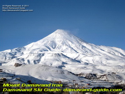
photo by Damavand Ski Guide
Climbing the Doberar Ridgeline
Bazm Chal is the western peak of the Doberar massif and is the lowest of the named peaks. It rises directly above the Haraz Road and can be used as a starting trekking point and access route to reach the top of the ridgeline. After ascending to the summit of Bazm Chal, most climbers follow the ridge-top east to reach the other peaks of the Dobrar Ridgeline. Traversing the entire ridgeline, depending on the climber’s stamina and skills, generally takes a little more than a week to finish. The best view from Bazm Chal’s summit is of Mount Damavand’s 5670-meter-tall gigantic cone, which is to the north. Unfortunately, the Haraz Road’s traffic noise may be heard halfway up the Bazm Chal hills.
Eastern Doberar Peak
One of the tallest peaks in the Dobrar mountain range, East Dobrar Peak is 4080 meters high. The eastern Dobrar peak can be reached by travelling from the end of Havir village up the river to the Great Spring, then continuing on to the Dobrar pass and the eastern Dobrar peak from there. 3100 Chehel Cheshmeh Summit.
Doberar Peak wintertime weather
The pinnacle of the Dobrar mountain range has hard and perilous winter weather the same as Mt. Damavand weather. Throughout the winter and into the early spring, repeated avalanches continue to fall on the northern and southern flanks. Large snow masks are forming at the ridge’s edge. It takes adequate winter climbing skills and full climbing gear to reach the region’s peak.

Wild Skiing in Doberar Ridgeline
Skiers seeking a wilderness experience frequently travel to Doberar, Angemar, Chengizchal, … peaks on the northern slopes for backcountry ski and ski mountaineering in Iran. Late March to mid-April are the ideal months to go skiing in the area. From the top of the point (over 4000 m), skiers can descend to the settlement of Lasem at 2550 m. The valley that runs between the peaks is the ideal place to ski down. In a year with above-average spring snow cover and decent snow conditions, you may find uninterrupted ski-able snow down to Lasem Village. Skiers must ascend the hard slopes of the stated valley from the settlement of Lasem to reach the different Doberar summits.
Iran’s summits of Alam Kuh (4848 m) and Damavand (5671 m). are used for ski touring. For backcountry skiers, the Alborz Mountains, which are located north of Teheran and include Mount Damavand ski touring as their highest peak, nonetheless remain a true mystery. The Doberar Mountains and Alam Kuh ski tours have sturdy slopes that are never tracked and make for the best acclimatization terrain.
Most tour operators advise commencing the ski touring in April and early May, when the conditions are often ideal, to enhance the likelihood of reaching Mount Damavand’s summit. At 5,000 meters, there are frequently severe winds, a very significant avalanche risk, and low temperatures at the beginning of April. Despite our best efforts, it might still be required to carry our skis on our backs as we ascend the last few vertical meters.
Fitness and Skill Level
Participants must be physically capable of hiking for 4 to 6 hours a day with up to 1600 vertical increases. It’s essential to have sure feet and good backcountry skiing technique, especially kick turns for the ascent. To reach the bivouac of the Damavand resort at 4,200 m, one must carry a somewhat hefty backpack with a sleeping bag, sleeping pad, and food for 24 hours.
Getting acclimated for Iranian ski vacations For ski mountaineers, the Alborz range, which has Damavand mountain (5,670 m) as its highest peak, is still a well-kept secret. Even experienced mountaineers must ensure proper acclimatization at these altitudes.
We advise acclimatizing either in the Doberar Mountains or at Alam-Kuh depending on the amount of snow and the weather. The other acclimatization zone is at Damavand Bargah Sevom, 4,200 m, or with an elevation of 4.848 m, Alam Kuh offers also acclimatization. In the Doberar area and Lasem ski zone, you stay with locals in Lasem local house or Polour climbing resort. In the final two weeks before departure, we advise taking either one or the other of the ski tours to an elevation of at least 3,500 meters. These tours’ acclimatization will be effective for up to three weeks.

Mount Damavand Climbing Campsite
Damavand Camp goes by multiple names, such as Damavand Base Camp, Damavand Camp II, and the second camp on the mountain. Locals refer to it as Goosfand-Sara (گوسفند سرا ), meaning “sheepfold,” or the Saheb al-Zaman Mosque (مسجد صاحب الزمان ) campsite. This key stop offers basic amenities for climbers and trekkers, allowing them to rest and prepare before ascending Mount Damavand.
It is the most accessible and well-known starting point for expeditions on Mount Damavand. The camp provides necessary facilities like a mountain refuge, the Saheb al-Zaman Mosque, and a sheepfold. Perched at 3,040 meters and located at Latitude 35.9020° and Longitude 52.1094°, it serves as the main base camp for those climbing the south route, especially in the summer. This is the primary spot for rest and preparation before the ascent begins.
Mount Damavand Explained: Location, Height, Rankings, and Everything You Need to Know
Mount Damavand is an iconic mountain that has captivated the hearts of adventurers for centuries. Located in the Alborz mountain range in northern Iran, it holds the title of the highest peak in the Middle East at 5,671 meters. This detailed explanation covers everything you need to know, including the mountain’s geographical location, its global ranking, and the significance it holds both in nature and culture. Whether you’re planning a climb or simply fascinated by its grandeur, this guide provides all the essential details.
Certified International Damavand Ski Guide
Mount Damavand Ski Tour Guide: Unique Adventures in Winter. While Mount Damavand is known for its challenging climbs, it also attracts winter sports enthusiasts, particularly skiers. The mountain’s unique geographical features and snowy conditions make it an ideal destination for ski tours. Hiring a Mount Damavand ski tour guide ensures a safe and exhilarating adventure as you navigate the slopes of this iconic peak. These certified experts are well-versed in the best skiing routes, providing you with the necessary equipment, safety instructions, and guidance to make your experience both enjoyable and safe. Skiing down the pristine snow of Mount Damavand is an unforgettable experience that offers a different perspective of the mountain’s beauty, one that only a professional guide can unlock.
Damavand & Alam Kuh Climbing Tour (Best Price & Itinerary)
The Damavand & Alam Kuh climbing tour is perfect for adventurers seeking the best price and itinerary for two of Iran’s most famous peaks. This combined tour package offers guided climbs on both Damavand and Alam Kuh, providing a once-in-a-lifetime experience filled with breathtaking views. The trek includes expert guides, accommodations, and exciting Damavand trekking and climbing tours that prioritize safety and enjoyment. Throughout this unforgettable journey, you’ll experience the thrill of tackling both mountains while appreciating the stunning landscapes that surround them, making it a must for any outdoor enthusiast looking to explore Iran’s natural wonders.
Mount Doberar 25GUD0102F
Ahaa, its nice conversation about this article here
at this web site, I have read all that, so at this time me also commenting here.
It’s not my first time to pay a quick visit this website, i am visiting
this site dailly and obtain good information from here daily.
Mount Doberar, spans about 70 kilometers, has several lofty summits, including Bazmchal, Chengizchal (formerly Chengeh-chal), Parvaneh, Angmar, Doberar, Suzchal, Qaradagh, Qiyag-lake, and Shah-tape.