
Damavand Camp – Takhte Fereydoun Camp
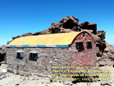
Takhte Fereydoun Shelter, located on the north-east route of Damavand, was built in 1976 by climbers from the University of Tehran, Technical College. The shelter sits at an altitude of 4,380 meters and can accommodate 20-25 climbers, with space around it for additional tents. In the summer, water is available from a small spring, fed by snowmelt, on the shelter’s northern side. The shelter has two floors. The trail to the summit is rocky and covered with snow and ice.

Damavand Northeast Attraction
The northeast face of Mount Damavand is renowned for its natural beauty, with abundant vegetation and water sources. It is more challenging to reach than other faces of the mountain, and its protected status has made it a safe haven for endangered animals. These factors contribute to the pristine and untouched nature of the northeastern side.
Summit the Middle East’s highest peak with Damavand-Info Climbing Tour Agency, the region’s most experienced mountain trekking tour operator. We offer safe, Damavand-guided trekking tours and expeditions for all skill levels, supported by expert guides. Choose from hiking, trekking, skiing, and climbing tours to conquer Mount Damavand in Iran.
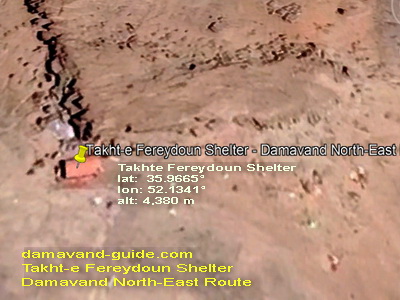
Takht Fereydoun Shelter
The Takht Fereydoun Shelter is built from stone with a metal roof. Most of the eastern trail is well-defined, starting from Gardaneh-Sar and leading to the beginning of the northeast ridge. It takes about 6 hours to reach the shelter (lat: 35.9665°, lon: 52.1341°). Along the way, there are two spots where you can access water from snowmelt, but it is advisable to avoid drinking it if you are not used to it.
On the Slope Leading to Takht Fereydoun Shelter, about 100 meters from the Takht Fereydoun Shelter is the last spot where you can retrieve water from the glaciers. Located on the edge of the Yakhar glacier, the shelter accommodates up to 25 people, with additional space around it for tents. At this altitude, the air pressure is approximately 535 mm Hg.
Acclimatization
After arriving at the shelter, take a short break, leave your belongings, and continue on the trail to Yakhar Ridge. Climb to an altitude of about 4,800 meters and stay there for an hour to help your body adjust to the altitude. Explore the shelter, then return for a light dinner and prepare for the climb the next day. To save time, pack and prepare your one-day backpack (attacking backpack) the night before climbing Damavand.
Takht Fereydoon Camp
Takht Fereydoon, or Takht-e Fereydoun, is an excellent place to camp and spend the night. The area offers both water from snowfall and wind protection on the ridge by the refuge. However, reaching Damavand’s summit in the morning requires a strenuous one-hour climb. The Takht Fereydoun shelter, located at an altitude of 4,388 meters, can accommodate 20-25 people.
Geographical Coordinates
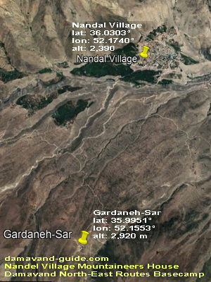
Nandal Village
- Latitude: 36.0303°
- Longitude: 52.1740°
- Altitude: 2,350 m
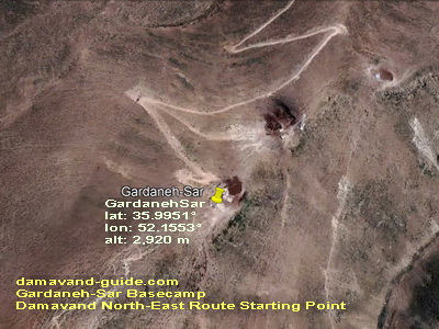
Gardaneh-Sar
- Latitude: 35.9951°
- Longitude: 52.1553°
- Altitude: 2,920 m
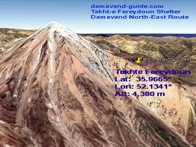
Takhte Fereydoun Shelter
Altitude: 4,380 m
Latitude: 35.9665°
Longitude: 52.1341°
Takht-e Fereydoun Shelter History
Source: The Project of Constructing Takhte Fereydoun Shelter
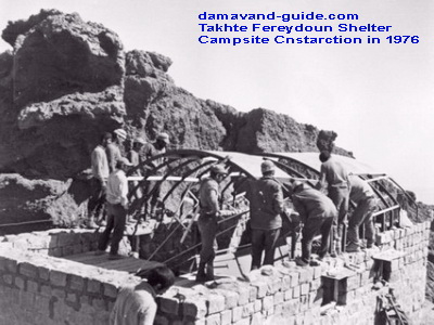
In December 1974, Hadi Mostofi and two other mountaineers, all climbers and students from Tehran University’s technical department, undertook a procurement program to identify and label the Mount Damavand North Ridgeline Route. They successfully ascended Damavand Peak.
However, after reaching the summit, Hadi Mostofi slipped and fell several hundred meters down a steep, icy slope on the eastern “Dubai Sel” Takht Fereydoun, near the glacier. His lifeless body was found at an elevation of about 5,000 meters on the “Dubai Cell” glacier. In June 1976, Siros Rizvan Ghah-Farokhi, a newcomer to the technical faculty’s climbing courses, also perished from a fall off the glacier’s cliff.
To enable winter climbs of Damavand Peak and to honour the memories of these two tragedies, the climbing team from the technical faculty decided to build a shelter along the same ascending path. Planning, purchasing, and coordinating the shelter’s construction began during the first summer break of the same year. By mid-September 1976, more than 200 climbers from the technical faculty, other faculties at Tehran University, and other universities helped build the shelter at an altitude of 4,400 meters in an area known as Takht Fereydoun. This location, a flat area protected by rocks, serves as a rest and overnight lodging for climbers aiming to ascend Damavand via the northeast ridge.
The first Damavand shelter, Bargah Sevom Shelter, was constructed many years ago on the southern path to the peak. Although the southern ridge offers the quickest and shortest path to the summit, winter climbs are extremely risky due to avalanches in several areas of the south route. Consequently, few winter ascents of Damavand Peak were made via the south face at that time, necessitating the construction of a shelter on a route suitable for winter ascents.
The northeast ridge, beginning from Gazaneh or Nandal villages, is the most effective route for winter ascents of Damavand. Takht Fereydoun serves as the best site to camp and recuperate before the final climb. The ascent of “Menar” continues along the ridge, passing by “Gosfand Sera.”
Other names and spellings of Takhte Fereydoun Shelter
Takht-e Fereydon refuge, Takhte Fereydoon camp, Takht Fereydoun campsite, Janpanah Takhte Fereydoun
in Farsi: پناهگاه تخت فریدون, جانپناه تخت فریدون
Known by several names, Damavand Camp is also called the Damavand Base Camp, Damavand Camp II, or the second camp on Mount Damavand. Locals refer to it as Goosfand-Sara (گوسفند سرا ), meaning "sheepfold," or the Saheb al-Zaman Mosque (مسجد صاحب الزمان ) campsite. This location is a vital checkpoint for climbers and hikers before they make their ascent, providing basic necessities and shelter.
As the most popular and accessible starting point for Mount Damavand, this camp offers essential facilities, including a mountain refuge, the Saheb al-Zaman Mosque, and a sheepfold. Sitting at an elevation of 3,040 meters, with coordinates of Latitude 35.9020° and Longitude 52.1094°, it’s the primary base camp for climbers on the south route, especially during the summer. This camp provides an important resting and preparation spot before the climb.
Iran’s Mount Damavand: Detailed Guide to Its Facts, Figures, and Fascinating History
Iran’s Mount Damavand is more than just the tallest peak in the country—it is a natural and cultural icon. In this detailed guide, you will discover key facts, such as its height of 5,671 meters, and the geological history that makes it an active volcano. The mountain’s influence extends far beyond the natural world, with a rich cultural history rooted in Persian myths and literature. This guide delves into the historical and cultural significance of Damavand, along with important statistics about the mountain’s location, its role in outdoor sports, and its enduring allure to climbers and adventurers alike.
Certified Local Damavand Peak Hiking Guides
Certified Iranian Local Mountain Guides for Trekking and Climbing Mount Damavand, Iran. Climbing Mount Damavand can be a daunting task without proper guidance, which is why hiring certified Iranian local mountain guides is crucial. These guides are experienced professionals who know every inch of the mountain, from the challenging slopes to the most scenic views. Whether you’re an experienced climber or a first-timer, a local mountain guide offers a personalized approach to your climb, ensuring safety and providing guidance through every stage of the trek. Their deep understanding of the mountain’s terrain, weather patterns, and potential hazards ensures your experience is both safe and rewarding. Many of these guides offer both private and group tour packages, giving climbers the flexibility to choose the Damvand tour style that suits them best.
Damavand Tour
Join us for a Damavand Tour and experience the splendour of Mount Damavand, the highest peak in Iran. Our Damavand tours and expeditions are designed for climbers of all experience levels. Enjoy scenic hikes, tackle challenging climbs, and uncover local legends as you aim for the summit of the Middle East’s tallest mountain. Our guided tour packages range from intense winter climbs to more relaxed summer hikes. As the leading mountain climbing tour company and top trekking tour operators in the region, we excel in providing safe and exhilarating Damavand Guided Trekking Tours and Damavand Ski Touring Expeditions.
Each guided adventure is customized to fit your skill level, ensuring a safe and enjoyable experience. Our expert Local Damavand Mountain Guides provide the support and knowledge needed to help you conquer Mount Damavand. We offer a range of experiences, from hiking and trekking to skiing and climbing, designed to meet every explorer’s needs and guarantee a memorable journey. Damavand Info delivers outstanding services for solo hikers, climbing groups, and trekking tour companies. Our skilled guides in Tehran will assist you throughout your adventure. Contact us to start planning your Damavand adventure tours and experience the breathtaking beauty of this majestic mountain.
Takhte Fereydoun Shelter 25GUD0105E